
Detailed Map of the Kruger National Park
452km from South to North and 20,000 square kms to explore and discover
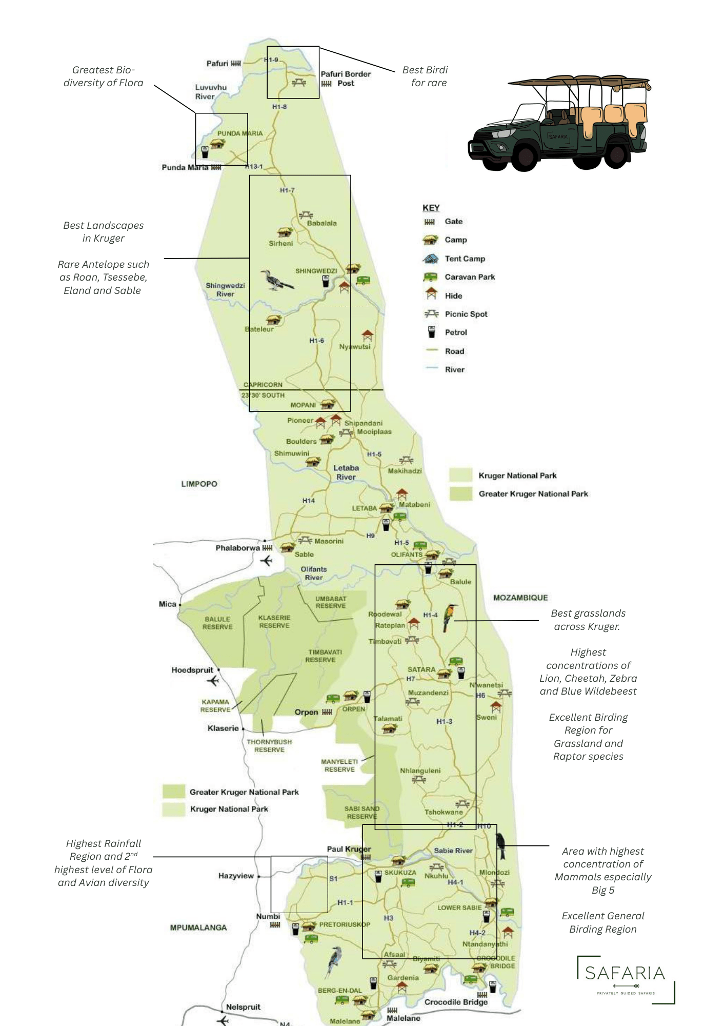
A COMPLETE LIST OF KRUGER NATIONAL PARK ROADS
MAIN ROARDS (TAR):
H1-1 – 50km – Tar road from Numbi gate east to Skukuza (Pretoriuskop camp – Shitlhave & Transport dams – Wolhuther waterhole – Mathekenyane/Granokop lookout access).
H1-2 – 40km – Tar road from Skukuza north to Tshokwane picnic spot (Skukuza day visitors picnic spot – Mantimahle & Silolweni dams – Leeupan pan – Orpen stones & Kruger tablet alighting points).
H1-3 – 50km – Tar road from Tshokwane picnic spot north to Satara (Mafagalamba, Matibyini, N’watinungu, Marheya water holes – Mazithi, Kumana dams – Southern-most Baobab).
H1-3 (this is a duplicated road number) – 3km – from H13-1 (Punda Gate Road) west to Punda Maria Camp.
H1-4 – 42km – Tar road from Satara north to H8/H1-5 junction (Olifants)(Witpens, Ntomeni, Nyamarhi & Ngotso North water holes – Ngotso dam – N’wamanzi lookout point – Olifants river high water bridge).
H1-5 – 24km – Tar road from H8/H1-4 junction (Olifants) north to H9/H1-6 junction (Letaba).
H1-6 – 108km – Tar road from Letaba north to Mopani & Shingwedzi (Malopenyana, Middelvlei, Klein Nshawu waterholes – Twisappel dam) 35km.
H1-6 – 108km (73km on MAP 4) – Tar road from Letaba north to Mopani & Shingwedzi (Bowerkop, Tsendze, Grysbok, Eendrag, N’wambu, Nkokodzi, Joao & Shipiriviri waterholes – Olifantsbad pan – Confluence lookout point – Tsendze bushveld camp – Mooiplaas picnic spot – Tropic of Capricorn cairn) 73km .
H1-7 – 49km (17km on MAP4) – Tar road from Shingwedzi north to H1-8/H13-1 (Punda gate road) junction (Lamont, Gorra & N’warihlangari waterholes) 17km.
H1-7 – 49km (32km on Map 5) – Tar road from Shingwedzi north to
H1-8/H13-1 (Punda gate road) junction (Boyela, Babalala, Dokweni, Mawawi, Shitangeni & Magamba waterholes – Babalala picnic spot) 32km.
H1-8 – 36km – Tar road from H1-7/H13-1 (Punda gate road) junction north to H1-9/S63 junction (Elandskuil, Mandadzidzi, Mashikhiri & Nkovakulu waterholes – Baobab hill).
H1-9 – 20km – Tar road from H1-8/S63 junction west to Pafuri Gate (access roads for Wilderness Safari Lodge & Outpost bushveld camp & Mashisiti waterhole)(Palm Springs waterhole on Outpost bushveld camp access/private road).
H2-2 (east) – 8km – Sand road from H3 (Afsaal Picnic Spot) east to S114 (Jock water hole).
H2-2 (west) Voortrekker road – 34km – Sand road from H3 (Afsaal Picnic Spot) west to Pretoriuskop & H1-1 (Voortrekker & Komapiti water holes – Jock’s birth place).
H3 Malelane – Skukuza Road – 53km – Tar road – Malelane gate north to (Skukuza) H1-1 (Afsaal picnic spot – Jock safari lodge – Kwaggaspan) (Renosterkoppies Dam access roads).
H4-1 Skukuza – Lower Sabie road – 46km – Tar road from Skukuza east to Lower Sabie (Nkuhlu picnic spot – Sunset dam).
H4-2 Gomondwane road – 35km – Tar road from Crocodile Bridge gate north to Lower Sabie (Gezantfombi & Makhohlola dams – Zambhala, Mpemane & Gomondwane water holes – Sabie river weir).
H5 Old Selati Rail Route road – 33km – Sand road from H4-2 (Gomondwane road) north then west to S114.
H6 Satara – N’wanetsi road – 19km – Tar road from H1-3 east to N’wanetsi picnic spot & lookout point & hide (Shishangani & Sonop water holes – Wenela dam – Singita Lembombo & Singita Sweni lodges).
H7 Satara road – 41km – Tar road from Orpen gate east to H1-3 (Satara) (Orpen camp, Maroela Caravan camp & Tamboti tented camp access roads – Timbavati River & Bobbejaankrans lookout points – Nsemani dam).
H8 – 10km – Tar road from H1-4/H1-5 junction east to Olifants Camp.
H9 – 52km – Tar road from Phalaborwa Gate east to Letaba Camp (Masorini & Erfplaas water holes – Rhidonda pan – Nhlanganini dam – small Nhlanganini river viewing loop to south).
H10 – 41km – Tar road from H4-2 (Lower Sabie) north to H1-2 (Tshokwane) (Loskop, Hillside, Muntshe, Mlondozi water holes – Nkumbe Viewsite & lookout points).
H11 – 12km – Tar road from Paul Kruger gate east to Skukuza (Lake Panic hide & Skukuza Nursery access roads to north).
H12 – 4km – Tar road from H4-1 (Skukuza – Lower Sabie Road) north to H1-2 (over Sabie river high water bridge).
H13-1 Punda Gate road – 20km – Tar road from Punda Gate east to
H1-7/H1-8 Junction (Thulamila waterhole).
H14 Mopani-Phalaborwa road – 53km – Tar road from H9 north to
H1-6 (Nandzana & Tsale water holes – Letaba river crossing).
H15 Giriyondo gate road – 22km – Sand road from H1-6 east 9km then north 13km to Giriyondo gate tourist access facility (Makhadzi picnic spot & lookout point – Malopenyana & Mbandzweni water holes – Manyeleti dam). Lamont loop – 3km – Sand road west of H1-7 near Shingwedzi along Mphongolo river.Orpen Dam loop – 10km – Sand road from H10 (Tshokwane) north to H1-3 (Orpen dam, alightment & lookout point).
SIDE ROADS ( GRAVEL ROADS)
S1 Doispane road – 30km – Tar road from Phabeni gate east to H11 (Albisini ruins – Nyamunwa dam)
S3 (north) Albasini road – 17km – Sand road from H1-1 (Numbi gate) north to S1 Doispane road (Mestel dam).
S3 (east) Sabie river road – 24km – Sand road from S1 (Doispane road) east to H11 Paul Kruger gate.
S4 – 4km – Sand road from S1 (Doispane road) north to S3 (Sabie river road).
S7 – 6km – Sand road from H1-1 (Numbi gate) north to S3 (Albasini road).
S8 Loop – 5km – Sand road from S14 Fayi loop west.
S10 Shabeni mountain loop – 2km – Sand road from S7 east (Pretoriuskop).
S11 Napi rocks loop – 4km – Sand road from H1-1 (Napi road) to south.
S12 – 5km – Sand road (loop) from H7 (Satara road) north to S40 (Girivana water hole).
S14 Fayi loop – 13km – Sand road from H1-1 (Numbi gate) south toH2-2 Voortrekker road.
S21 N’watimhiri road – 27km – Sand road from S114 (at Renosterkoppies dam) east to H4-1 Skukuza-Lower Sabie road (Nhlotini & N’watimhiri water holes & pans near H4-1.
S22 Loop – 3km – Sand road north from S112 to S114 (Renosterkoppies lookout point).
S23 Biyamiti loop – 14km – Sand road from S114 north to S114 (Muhlambamadvube water hole).
S25 Crocodile river road – 51km – Sand road from S114 east to H4-2 (Crocodile Bridge).
S26 Bume river road – 22km – Sand road from S25 Crocodile river road north then west to S114
S27 Hippo pool – 3km – Sand road from S25 Crocodile river road (near Crocodile Bridge) south to Crocodile River.
S28 Nhlowa road – 24km – Sand road from H4-2 Gomondwane road (Crocodile bridge) north to H4-2 Gomondwane road (Lower Sabie) (Mac’s water hole – old Nhlanganzwani dam – Ntandanyathi hide).
S29 (west) – 4km – Sand road from H10 west to S128 Old Tshokwane road (Mafotini water hole).
S29 (east) Mlondozi road – 14km – Sand road from H4-2 north then west to H4-2 (Mlondozi dam & Picnic spot north).
S30 Salitjie road – 18km – Sand road (along northern side of Sabie river) from H12 east to S128 old Tshokwane road (Salitjie river lookout point).
S33 Vutomi road – 19km – Sand road from H1-3 west to S36 Nhlanguleni road (Vutomi dam – Tinhongana water hole.
S34 Munywini road – S34 – Sand road from H1-3 (Tshokwane) west to S36 Nhlanguleni road.
S35 Lindanda road – 17km – Sand road from Orpen loop (Tshokwane) north to S37 Trichardt road.
S36 Nhlanguleni road – 66km – Sand road from H1-2 north to H7 Satara road (Jones-se dam, Manzimhlophe, Swartgat, Lugmag dams & Manzimhlophe, Sundvwini, Ngwenyeni, Mondzweni, Shimangwaneni dam, Rockvale water holes – Dyondzwana pan – Machaphiri Dyke – Nhlanguleni & Muzandzeni Picnic spots).
S37 Trichardt road – 36km – Sand road from H1-3 north to H6 Satara-N’wanetsi road (Guweni dam water hole – Sweni hide) MAP2
S39 Timbavati road – 32km (???) – Sand road from H7 Satara road north to H1-4 (Olifants)(Timbavati picnic spot – Piet Grobler dam – Ratelpan, Palm Springs, Roodewal & Goedgegun water holes – Ratelpan hide – Roodewal private camp) MAP2&3
S40 – 16km – Sand road from H7 Satara road north to Timbavati Picnic spot MAP2
S41 Gudzani road – 29km – Sand road from H6 Satara-N’wanetsi road (N’wanetsi) north to S90 Old Main road (Dumbana & Gudzani water holes – Gudzani dam) MAP2
S44 – 14km – Sand road from S93 (Olifants) east then north along Olifants & Letaba rivers to S93 at Von Wielligh’s Baobab (Olifants lookout point).
S46 – 19km – Sand road from H1-5 east then north along Letaba river to S94 (Engelhard dam).
S47 Letaba river road – 28km – Sand road from S131 north to Mingerhout dam lookout point then south/east (along Letaba River) to H1-6.
S48 Tsendze loop – 17km – Sand road north from H1-6 along eastern banks of Tsendze river.
S49 – 11km – Sand road from S50 north to H1-6 (Mooiplaas water hole).
S50 Nhlawu Vlei – Dipene road – 79km – Sand road from H1-6 north to Shingwedzi (Nshawu No1, Nshawu No3, Nshawu, Dipeni & Mashangadzi waterholes – Shibavantsengele lookout point – Grootvlei & Kanniedood dams – Nyawutsi & Kannidood hides) + (S50 west branch to Mooiplaas water hole).
S51 Masorini loop – 5km – Sand road from H9 (Phalaborwa) south then north to H9 (Sable dam & Sable overnight hide – Masorini Archaeological site lookout point).
S52 Shingwedzi river loop – 40km – Sand road from H1-6 west then east/northeast to H1-6 at Shipirivirhi waterhole (access road to Bateleur bushveld camp (with Rooibosrant & Silvervis dams on no entry road) – Red Rocks & Tshanga lookout points – Joao & Shipirivhi waterholes).
S56 – 30km(15km on MAP 4) – Sand road from H1-7 north to H1-7 at Babalala Picnic spot (runs east of Mphongolo river & Sandpiper waterhole & after 12km a 3km link road east to H1-7).
S56 – 30km (15km on MAP 5) – Sand road from H1-7 north to H1-7 at Babalala Picnic spot (runs east of Mphongolo river)( Mavatsani waterhole & access road to Sirheni Busveld camp with Sirheni dam).
S57 – 5km – Sand road link from H1-7 (at Boyela waterhole) west to
S56 (at Sirheni access road junction).
S58 Dzundzwini loop – 5km – Sand road from H1-7 west to H13-1 Punda Gate road (Dzundzwini spring access).
S59 – 7km – Sand road from H1-8 northwest to S60 (Mandadzidzi waterhole).
S60 – 16km – Sand road from H1-8 west to H13-1 Punda Gate road.
S61 Klopperfontein Drift loop – 7km – Sand road from H1-8 west then south to S60.
S63 – 9km – Tar road from H1-8 & H1-9 junction east to Pafuri Port of Entry (after 4km link road of 2km north to S63 – at eastern end link road of 1km to S63).
S63 Luvuvhu river road – 11+1km – Sand road from H1-9 east to Pafuri Port of Entry (Pafuri picnic spot – Fever Tree forest & vlei – Crooks Corner).
S64 Nyala road – 5+2km – Sand road from H1-8 west & back at H1-9 & S63 junction (runs south of Luvuvhu river) (Bobomeni Drift Historical Site & Thulamela Archaeological Site).
S65 Waterhole road – 14km – Sand road from H1-1 north to S1 Doispane road (Nwaswitshaka water hole).
S69 – 6km – Sand loop to south of H9 (Letaba) (crosses Nhlanganini River).
S79 N’watimhiri causeway loop – 4km – Sand road north of H4-1 (Skukuza-Lower Sabie Road) (at confluence of Sabie & N’watimhiri Rivers).
S82 Mativuhlungu loop – 10km – Sand road from H4-2 north to H4-1 (Lower Sabie).
S83 Marula loop – 7km – Sand road north of H1-2 (junction north of
H1-2/Sand River Bridge).
S86 N’waswitsontso loop – 4km – Sand road west of H1-3 (along the north of the N’waswitsontso river) MAP2
S89 Ngotso Weir road – 8km – Sand road from H1-4 east to S90 Old main road MAP3
S90 Old main road – 43km – Sand road from H1-4 (Satara) north to S91 (Balule) (Balule, Reitz Pontoon in Olifants river) (Mavumbye, Gudzani & Bangu water holes – Shitsalaleni pan).
S91 – 5km – Sand road from H1-4 south-east to S90 Old Main Road &
S92 junction (at Olifants River/Balule).
S91 – 7km – Sand road from S91 & S90 (Old Main Road) junction (at Olifants River Balule) north to H8 (Olifants).
S93 – 16km – Sand road from H8 (Olifants) north to Von Wielligh’s Baobab then north/west along western bank of Letaba River to S46.
S94 – 10km – Sand road from S46 north to Letaba at H1-5/H1-6/H9 junction.
S96 Shilawuri loop – 5km – Sand road from H9 (Phalaborwa/Letaba Road) north to S131.
S99 Mahonie loop – 25km – Sand road from H13-1 (Punda Maria camp) west then north then east to H13-1 (Punda Maria Camp) (Coetzer & Witsand waterholes – Matukwale dam).
S100 N’wanetsi River Road – 21km – Sand road along northern bank of N’wanetsi River – from H1-3 (at H1-3/H7 junction) east to S41 Gudzani road (Shibotwana & Nsasane water holes).
S102 – 8km – Sand road from S26 Bume road north to H5 Old Selati Rail Route (Buffeldorings water hole – Mpondo dam).
S106 Rabelais loop – 11km – Sand road from H7 (Orpen) to H7 (Bobbejaankraans) (Rabelais pan – Rabelias Hut alighting Point).
S107 – 2km – Sand road from S28 Nhlowa road east to old Ntandanyathi Dam.
S108 – 3km – Sand road from S26 Bume Road north/east to H5 Old Selati Rail Route (crosses Bume River) (Gayisenga water hole & lookout point).
S110 (Tarred section) – 10km – Tar road from H3 (Malelane Gate) to Berg-en-Dal Camp (Malelane Camp access road).
S110 (Sand section) Matjulu Loop – 13km – Sand road from Berg-en-Dal Camp west then north then east to H3 (access to Matjulu water hole).
S112 – 4km –Sand road from H3 east to S114 (Renosterkoppies access road).
S113 – 2km – Sand road from H3 east to S23 Biyamiti Loop.
S114 (Old Main Road from Malelane Gate to Skukuza) – 51km – Sand road from H3 (Malelane Gate) north to H1-1 (Biyamiti weir – Renosterkoppies dam – Stevenson-Hamilton Memorial Tablet) (Biyamiti Bushveld Camp access).
S118 Mlambane River Road – 8km – Sand road from H3 Malelane-Skukuza Road east to S114 (Ampie-se-boorgat water hole).
S119 Mlambane River Road – 6km – Sand road from S114 east to S25 (Gardenia hide).
S120 Steilberg Loop – 8km Sand road from S110 (Matjulu Loop) north to H3 Malelane-Skukuza Road.
S121 Timfenheni Loop – 6km – Sand road from H3 Malelane-Skukuza Road east to S114.
S122 Muntshe loop – 13km – Sand road from S29 Mlondozi road north to H10.
S125 N’waswitsontso road – 14km – Sand road along northern bank of N’waswitsontso River from H1-3 west to S36 Nhlanguleni road (Kumana West & Mhisanamond water holes) MAP2
S126 Sweni Road – 22km – Sand road north of Sweni River from H1-3 west to S36 Nhlanguleni road (Sweni, Welverdiend & Muzandzeni water holes – Mahungumula pan).
S127 Ntomeni Road – 9km – Sand road from H1-4 west to Timbavati picnic spot.
S128 Old Tshokwane Road – 31km – Sand road from H10 (Lower Sabie side) north to H10 (Tshokwane side) (Phambana Pans).
S129 – 4km – Sand road from H10 west to S128 Old Tshokwane Road crosses Mlondozi River.
S130 Gomondwane loop – 13km – Sand road from H4-2 Gomondwane Road (Crocodile Bridge side) north to H4-2 (Lower Sabie side) (Duke’s access road).
S131 – 16km – Sand road from H9 (Phalaborwa Gate) north then east crossing over H14 Mopani- Phalaborwa Road to H9 (Letaba Camp) (Ngwenyeni, Shivhulani & N’wanetsi water holes – Shipukuyila pan).
S132 – 7km – Sand road from H9 (Phalaborwa-Letaba Road) north to S131.
S133 – 8km – Sand road from S131 north to H14 Mopani-Phalaborwa road.
S135 Loop – 4km – Sand road from Shingwedzi Camp north to H1-7.
S136 (Boulders Bushveld Camp Private Road) – 16km – Sand road from H14 Mopani-Phalaborwa Road at Tsale water hole north to S142/S146 junction
S137 – 8km – Sand road from S28 Nhlowa road west to S130 Gomondwane loop (Duke’s water hole & Windmill)
S139 (Biyamiti Bushveld Camp Private Road) – 18km – Sand road south of Biyamiti River from S25 Crocodile River Road west to S114
S140 – 31km – Sand road from S106 Rabelais loop (Orpen Camp side) south then east to S36 Nhlanguleni road (Mahlabyanini, Talamati, Fairfield & Mondzweni water holes – Talamati Bushveld Camp – Hoyo Hoyo Tsonga & Imbali Safari lodges access roads)
S141 (Shimuwini Bushveld Camp Private Road) – 12km – Private sand road west from H14 Mopani-Phalaborwa Road with 8km loop to the south of S141 along north of Letaba River
S142 Shongololo loop – 40km – Sand road from H1-6 (south of Mopani Camp) northwest then northeast to H1-6 (north of Mopani Camp) (Shipandani Overnight & Pioneer Hide – Pioneer dam – Frazersrus & Welgelegen water holes – Mitomeni & Outspan pans – crosses Tropic of Capricorn)
S143 Tropic of Capricorn loop – 16km – Sand road from S50 Nhlawu Vlei – Dipene Road west to S144 Old Main Road (crosses Tropic of Capricorn – Tihongonyeni waterhole – N’wambu pan)
S144 Old Main Road – 36km – Sand road from H1-6 at Tropic of Capricorn Cairn north then west to H1-6 at Nkokodzi water hole (Dzombo West waterhole)
S146 – 19km – Sand road from S142 Shongololo Loop/S136 junctio southwest to Joubert’s grave & Stapelkop dam lookout point